1stAugust. Crew logistics are often quite complicated when sailing – journeys often involve multiple modes of public transport. This morning we waved goodbye to two of our crew members: Andy and Matthew took the ferry back from Islay (then bus, train and car) while Grace and Gayle stayed on board for the journey to Ireland.
The land-based logistics were matched by hours of passage planning for the sailors; tides run strongly in the North Channel between Scotland and Ireland. This meant careful planning to account for the tide sweeping east across our path, and precise timing to arrive at the western entrance to Rathlin Sound at slack water to avoid potentially rough water (‘overfalls’) that were warned of by the pilot books and by other sailors. Their warnings seemed credible – Rathlin Island is surrounded by wrecks and it is not without reason that this small island has no fewer than three lighthouses.
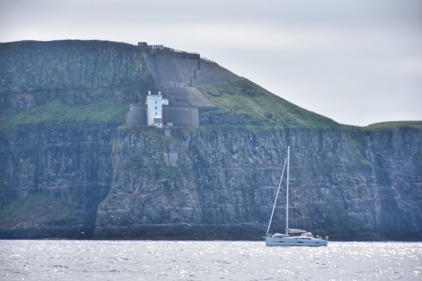
We left Port Ellen at 7.30am, feeling a little sad as we left the lovely wild scenery of Scotland behind us to travel south. As forecast the wind dropped part-way through the passage so we unfurled our gennaker and kept our average speed between 5 and 6 knots, arriving precisely when we had planned. This was theoretically at slack tide, but tides don’t always behave quite as expected: as we approached Rathlin, the stream was still running west at 1.5 knots, and by the time we rounded the impressive Bull Point with its lighthouse perched halfway up the cliff there was disturbed water and we found that we had 2 knots of tide against us running east, so progress into the little marina at Church Bay was slower than we’d hoped. We were reassured speaking to the harbourmaster to find that the tides are notoriously difficult to predict around Rathlin and locals might have had exactly the same experience.
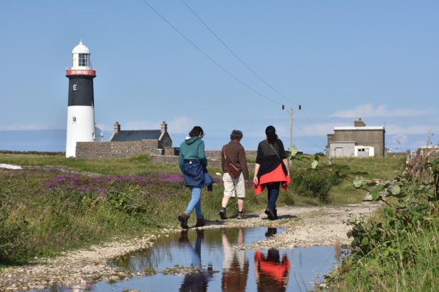
We spent the afternoon in glorious sunshine exploring the island. There is a tiny collection of houses and a ferry pier (mainly for day-trippers) at Church bay, and roads leading to each side of the island which is seven miles end-to-end. We took the road east, and were soon walking through purple heather and yellow gorse, with a clear view east to the Mull of Kintyre and south to the Irish mainland.

Near the lighthouse, Marconi made the world’s first commercial radio transmissions to Ballycastle on the mainland, for Lloyds insurers, signalling the safe arrival of ships from America. We could see rough water to the north east of the headland: the MacDonnell race, named after the MacDonnell brothers, who were drowned returning to Rathlin when they were caught in a vicious tide race. Their father watching from land raised his arm as if to move the boat’s tiller to steer them out of harm’s way. Legend has it that his arm stayed in the same position for the rest of his life.
We called into the boathouse visitor centre (kindly let in ‘after hours’ by the lady on duty) which has a fascinating collection of artefacts and information about the island, and later that evening enjoyed listening to traditional music being played in the bar. We felt like we’d arrived properly in Ireland.
- Distance: 29nm. Sailed 5h45m
- Wind: NW3-4
ABOUT THIS BLOG
On our passage ‘Around These Islands’ Anne is writing about each trip, and Jonathan is writing some more ‘technical’ blogs, from our perspective as ordinary cruising sailors. We are sharing what we’ve learned, and welcome your thoughts too. Please remember that this blog – and your comments – are public.
There’s also a special focus on 12 key ports on our planned route, with articles from These Islands and a series of podcasts from Chrome Media called ‘Around These Islands in 12 Ports’.
FOLLOW US
You can like, share and follow us on social media for latest images and impressions:
- Latest updates (via public Facebook page)
- Daily Sky images (via Twitter)
- Photographs (via Instagram)
- Latest position (from VesselFinder)
