13thAugust. We slipped our lines from lightship Petrel at 11.25am to motor-sail in very light winds down Strangford Lough, aiming to catch the first of the ebb tide out of the narrows. A few harbour porpoises swam past us and we had lovely views of Portaferry on one side and Strangford village on the other. Once out we were taken by surprise at the strength of the wind: the forecast had suggested gentle southerly winds and we were expecting to do quite a bit of motoring. Not so – the wind was blowing between 15-20 knots from the south east so we reefed our main and set off for a long haul tacking upwind. That meant the 27 miles from Strangford to Carlingford entrance turned into about 40 miles.
It was sunny and dry and we had a good view of the Mourne mountains getting ever closer. Tidal streams are strong in the entrance to Carlingford so we’d timed our arrival so we arrived mid-flood tide. It is close to spring tides, so we were expecting a very strong current, but in fact there was no more than 3 knots of tide at any point, which swooshed us along nicely but didn’t feel difficult to manage. The border between Northern Ireland and the Republic runs down the middle of the lough, and the well buoyed channel runs past the ferry terminals on the south side and the pretty village of Greencastle on the north side, which has the Mourne mountains as an attractive back-drop in the north. On the shoreline to the south are the Cooley mountains, so it is high on both sides and is a ‘true fjord’ (glaciated formation) but wide and mostly very shallow. We turned towards the hills and into the marina at 8.15pm, ready to stop after a long and tiring sail. The weather the following day was wet and the wind still from the south so after a back-and-forth decision we decided to stay put.
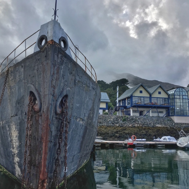
The marina is slightly out of the town and its most notable feature is the rather ugly hulk of the ‘Cretegaff’ which acts as a walkway from the pontoons to the marina buildings: intrigued, we googled it and after some searching discovered it was one of six tugs built from concrete early in the 20thcentury, all named ‘Crete…’. Together with the dilapidated concrete harbour walls, narrow entrance, and dark setting under the hills it isn’t the most attractive setting if you’re sitting in a boat, but there’s an attractive new bar and Indian restaurant with a good view over the lough so this family-run business is clearly trying to attract people from land and sea.


The rain cleared and we walked into Carlingford which is an old settlement, with the remains of medieval town walls and a ruined castle overlooking the harbour. We followed one of several well-marked walking routes along a wooded track high above the lough, with a view of the whole lough from the entrance to Warrenpoint at the western end, and back along the Greenway, an old railway track which has been turned into a lovely walking and cycling route along the edge of the lough.
- Distance: 50 nm. Motored 1h (in Strangford Lough), sailed 7.5h
- Wind: S/SE 4-5
ABOUT THIS BLOG
On our passage ‘Around These Islands’ Anne is writing about each trip, and Jonathan is writing some more ‘technical’ blogs, from our perspective as ordinary cruising sailors. We are sharing what we’ve learned, and welcome your thoughts too. Please remember that this blog – and your comments – are public.
There’s also a special focus on 12 key ports on our planned route, with articles from These Islands and a series of podcasts from Chrome Media called ‘Around These Islands in 12 Ports’.
FOLLOW US
You can like, share and follow us on social media for latest images and impressions:
- Latest updates (via public Facebook page)
- Daily Sky images (via Twitter)
- Photographs (via Instagram)
- Latest position (from VesselFinder)

Cretegaff is a unique ship, the last of six ferro-cement Tugs built by John Ver Mehr & Co at Shoreham on Sea, Sussex that floats today. Her sister ship Creteboom lies abandoned in the River Moy, Ballina in Co. Mayo. Cretegaff was repaired, refloated and recovered from The River Boyne at Drogheda by Mr Moneley in 1987 after a complex and costly salvaging exercise. Beauty is in the eye of the beholder of course and to me, she is an amazing and unique historic vessel. Were she ever to be painted, her providence would be lost..I am writing a piece on the history of the Cretegaff if you would be interested!
LikeLike